
Turn location data into decisions — faster
Pivvot delivers powerful spatial analytics through a robust software platform or directly into your own systems, giving you access to 500+ geospatial datasets, and accelerating your routing, site selection, land due diligence, and environmental reviews. You get actionable insights for smart decisions in minutes, not weeks. Get started with Pivvot.


Spatial analytics that give your team and organization location-driven intelligence to make crucial project and business decisions
Pivvot provides spatial analytics across the mainland United States to help GIS professionals, engineers, planners, utilities, energy developers, and AEC organizations answer complex, location‑driven questions related to land, infrastructure, environmental risk, and asset planning.
Spatial analytics questions Pivvot helps your team answer
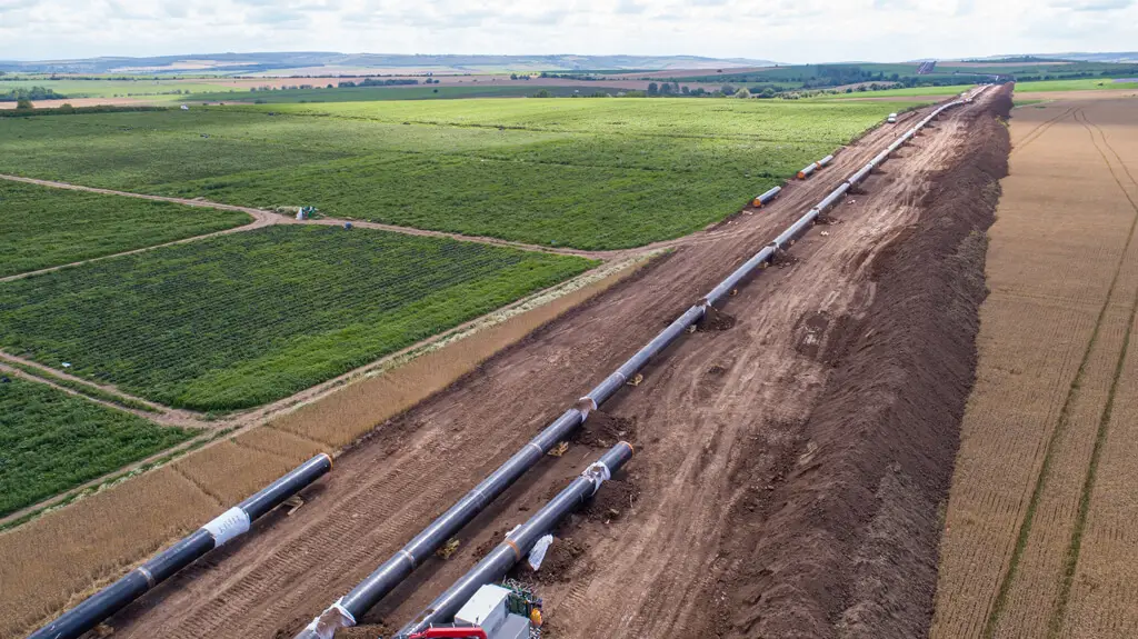
Infrastructure and route optimization
- What route is optimal for my pipeline?
- What route has the fewest environmental constraints to connect a new state highway to an existing interstate?
- What crossings and impacts are present on the electric transmission route we’re considering?
With Pivvot, you can compare route alternatives using parcel boundaries, environmental constraints, regulatory crossings, and existing infrastructure to objectively identify the most viable and lowest‑risk corridors for your project.

Site selection and development planning
- Where are the nearest power sources for our proposed data center project?
- Where are the best sites that we should consider for our infrastructure project?
- Where are brownfield sites on the East Coast region that I can consider for building?
Pivvot enables data‑driven site selection by analyzing location factors, including land availability, redevelopment potential, proximity to power and infrastructure, and regional constraints, to provide the most feasible development options so your project has a strong foundation.
Land, parcel, and ownership analysis
- How many parcels does my pipeline cross and who owns them?
- Where can I find 300 available, contiguous acres for our next renewable energy project?
- How can I search for parcel details without alerting the landowner at this early stage?
Pivvot integrates nationwide Smart Parcels and ownership data to quickly quantify land impacts, identify owners, and evaluate contiguous acreage opportunities at scale across the mainland United States. You can evaluate and select the most effective site for your project before alerting or contacting the landowner.


Environmental risk and impact assessment
- What environmental risks exist around or on my proposed solar site?
- What are the environmental impacts along our proposed natural gas pipeline?
- What environmental permits will I need to plan for on this proposed project site?
Pivvot evaluates environmental constraints such as wetlands, floodplains, protected lands, and sensitive habitats to help teams assess risk early and avoid costly redesigns or permitting delays, ensuring your team focuses on sites or routes that better align with anticipated timelines and budgets.
With a subscription to the Pivvot platform or datasets, your team can find answers to all these questions and more in minutes, not weeks.
Smart Parcels – example shows parcels 200 acres or greater owned by the same entity
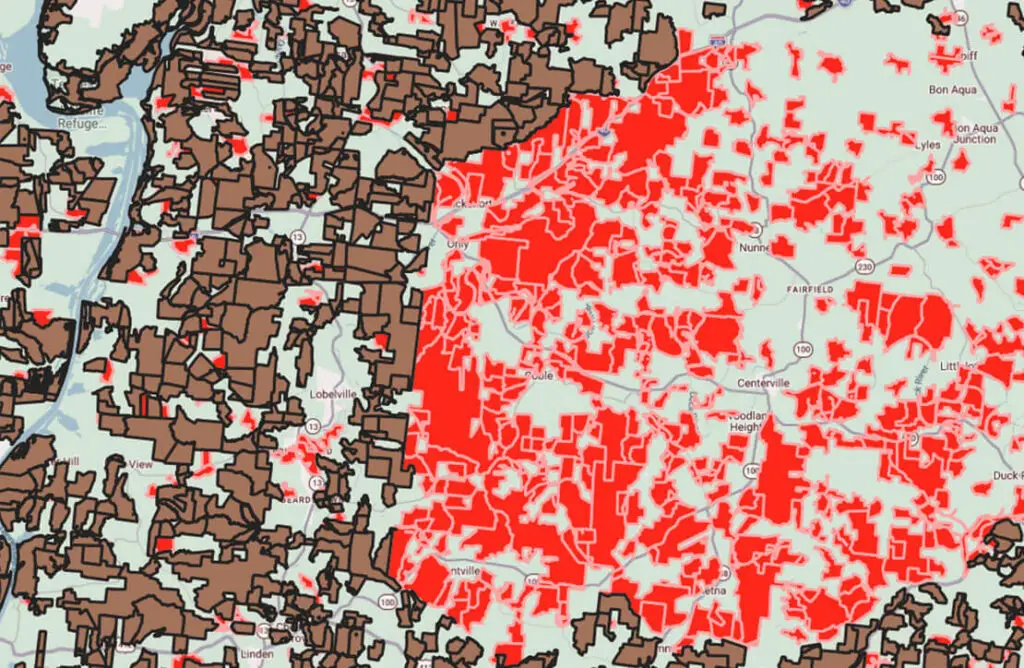
KEY
Brown = Tax map parcels 200 acres or greater
Red = Smart Parcels (merged tax map parcels owned by the same entity that combined are 200 acres or greater)
Green = areas are less than 200 acres
Pivvot data is continually refreshed for the most accurate and quality location spatial analytics available
500+ actively refreshed datasets in a familiar visualization sets your team up for success.
Pivvot collates data and places it in a single data repository, then transforms it to a standard visualization that is easily displayed on standard web maps of the mainland United States.
Pivvot displays multiple layers of data, including:
- Geotechnical aspects of the surrounding terrain, including geology, elevation, slope, and aspect
- Hydrology, including water bodies, wetlands, and aquifers
- Ecology, including critical habitat and land cover
- Land management, including ownership conflicts, structures, and easements
- Infrastructure, including transportation, railroads, pipelines, and powerlines
- Jurisdictions, including city, county, state, and governmental districts
Pivvot brings complex geospatial data into one standardized, map‑ready view—giving your team a clear, comprehensive understanding of terrain, environmental constraints, land ownership, infrastructure, and jurisdictions so you can make faster, more confident location‑based decisions.
Pivvot delivers high-confidence and quality geospatial data
The data that becomes part of Pivvot undergoes three rounds of quality control and assurance. Tests are performed to identify the veracity of the geometry (location) and structure of the geometry (overlaps, self-intersects, polygon complexity, number of vertices).
Pivvot aims to ensure that no data is more than 30 days different between the published and last-checked dates for federal data and 90 days different for state and county data. With Pivvot, you can be sure you are working with the most recent datasets available.
Read Our Data is the Difference
Easy-to-understand location context
No need to be a GIS professional or data analyst to use the Pivvot platform. Using our familiar interface, business leaders, developers, and project managers can easily visualize critical information anytime, anywhere.

Secure, compliant, and ready to work
Pivvot has SOC 2 Type II and ISO 27001 certifications, among others, and has required controls in place to govern the security of customer data. You can confidently use the Pivvot platform knowing your data remains your data and that Pivvot data is secure, compliant, and ready to work for your team.
Have more questions on Pivvot data security controls?

Turn a proposed site or route location into clear, actionable intelligence in minutes, not weeks, with a Pivvot platform subscription
With Pivvot, you and your team can:
- Upload your assets or third-party data to visualize any area of interest
- Toggle data layers on and off to view constraints across the mainland United States
- Download Pivvot data for your area of interest
- Collaborate easily with your team, clients, and partners on a fast, intuitive, familiar map-based interface
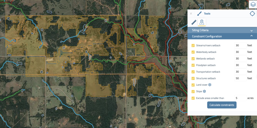
- Drop a point, draw a route or polygon, and instantly understand environmental and permitting risks
- Generate optimized, constraint-aware routes using your project criteria and Pivvot data
- Identify crossings and evaluate critical impacts for any linear corridor
- Understand jurisdictional boundaries and generate a list of permitting requirements
- Instantly produce parcel reports with ownership and other critical attributes
- Visualize project suitability and cost implications across multiple site options
Why Pivvot Data for your platform?
Pivvot data is standardized and optimized for GIS performance. Have your own proprietary or GIS platform? Pivvot data easily integrates into GIS platforms and provides AI-ready spatial data that is ready-to-use. No messy or inconsistent datasets or manual data processing required of your GIS data team.
We’ve done the work.
- Current, clean, structured datasets
- Easy to implement
- Ready to use
- Spatial data in hours, not weeks
- Simplified data access
Four ways to access Pivvot
Annual Pivvot platform subscription enables you to upload your own asset data and create projects with unlimited users within your organization.

Custom Integration – Your platform, our data. Access our ready-to-integrate spatial analytics data directly via custom integration API or secure digital file.

Pivvot Services – When time is short or your internal capacity is stretched, we become part of your team and turn your area of interest into actionable data that works seamlessly in your existing systems. Send us an area of interest and our team of experts and professionals will deliver reports and a file geodatabase to be used in any system. Learn more about Pivvot Services

DaaS – Access Pivvot data through Data as a Service (DaaS). We’ll provide Pivvot datasets to your GIS system via the Cloud, file transfer, API, or custom integration. You can subscribe to individual datasets or to the entire Pivvot database.
Ready to see what Pivvot can do for your team or enterprise?
Frequently Asked Questions
Is Pivvot a data provider or spatial analytics software?
Both. The Pivvot platform is offered as an annual subscription and delivers spatial analytics software with 500+ curated, actively refreshed datasets. If you only need data delivered to your proprietary or enterprise system, Pivvot offers our data as a Data as a Service (DaaS) subscription or user-specific data request purchase, enabling you to acquire the datasets you need or the entire Pivvot data database.
How often are datasets refreshed?
Datasets follow automated refresh cadences. You have access to the metadata to view exactly when the data was last refreshed, so your team knows exactly when the data was refreshed. For data-as-a-solution or user-requested specific data, datasets are updated according to subscription terms.
What sort of GIS file types can I export?
You can export KML, KMZ or File GDB.
Can I upload my own data to Pivvot?
Yes. You can add your company assets to the Pivvot platform and visualize their locations to best evaluate your potential site or route.
Is a trial of the Pivvot platform available?
Yes. Let’s connect so we know which software trial is right for your business: Aware, Siting, or Route.
Is Pivvot data available for all 50 states?
Is Pivvot data available for countries outside of the U.S.?
At this time, Pivvot datasets are only available for the mainland United States.