Build renewable projects with confidence—from site selection to routing
Pivvot delivers purpose-built data and analytics to accelerate renewable energy development. Whether you’re siting utility-scale solar, optimizing wind farm placement, or routing new transmission to connect clean energy to the grid, Pivvot provides the data clarity renewable energy teams need to make defensible decisions—faster.
Pivvot Route enables efficient corridor planning for transmission and collection systems that connect renewable generation to the grid.
Transmission and interconnection lines – Optimize routes around environmental constraints, protected lands, and permitting challenges
Collector systems for solar and wind – Design efficient, constructible pathways that minimize cost and impact
Pipeline and infrastructure routing (Hydrogen, CO₂) – Apply precise constraint analysis for emerging energy networks
Advanced routing analytics help you balance engineering feasibility, regulatory compliance, environmental constraints and risks, jurisdictional considerations, and project economics—while maintaining defensibility in stakeholder and permit reviews.
Pivvot Siting unifies hundreds of curated datasets to identify viable project locations early in development. Evaluate risks, constraints, and opportunities with precision for:
Utility-Scale Solar – Analyze topography, land ownership, environmental constraints, and proximity to interconnection points to prioritize constructible sites.
Wind Energy – Screen for environmental sensitivities, setbacks, and infrastructure access to support early feasibility and permitting.
Battery Energy Storage Systems (BESS) – Identify strategically located, low-risk parcels near substations and load centers.
Emerging Renewables (Hydrogen, Hybrid Projects) – Assess land suitability, water resources, and regulatory factors with comprehensive spatial insights.
Deliverable-ready outputs give your team a clear path forward—reducing early-stage uncertainty and costly redesigns.
Pivvot Siting: find buildable, grid‑ready sites with Smart Parcels
No more searching multiple data tools and databases to find the parcel, property owner, boundaries, assessed values, access constraints, or nearby hazards. With Pivvot and Smart Parcels, you can instantly view parcel boundaries, ownership, APNs, tax data, and assessed values; identify encumbrances, easements, setbacks, access constraints, and nearby hazards; create contact lists, summaries, and due diligence packets; and prioritize parcels using suitability scoring and custom criteria.
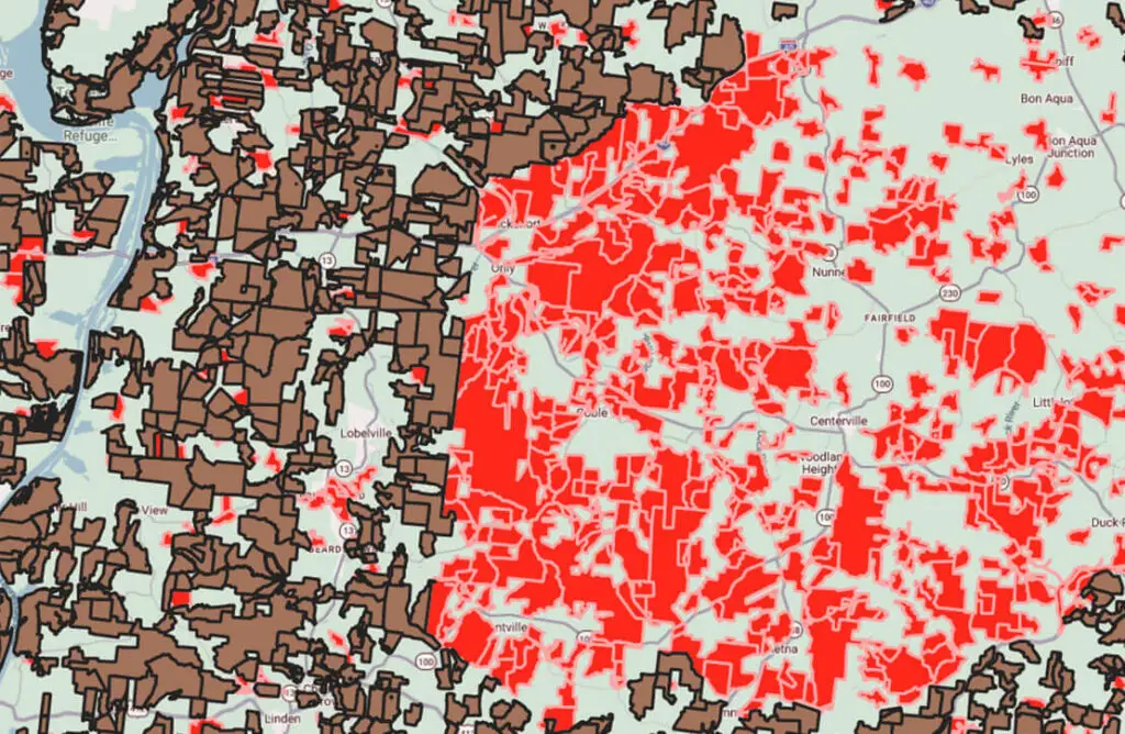
Example: Smart Parcels – example shows parcels 200 acres or greater owned by the same entity
KEY
Brown = Tax map parcels 200 acres or greater Red = Smart Parcels (merged tax map parcels owned by the same entity that combined are 200 acres or greater) Green = areas are less than 200 acres
Generate and compare multiple alternative routes from project areas to the grid in hours instead of weeks, while honoring preferred, avoid, and exclusion zones for wildfire risk, communities, and sensitive lands.
Colocate with existing transmission to reduce new right‑of‑way and permitting friction on major capacity additions and undergrounding initiatives.
Summarize every key interaction along a corridor with a Crossing & Impact Report showing railroads, pipelines, roads, wetlands, land‑use changes, segment lengths, and more—giving project teams a defendable view of cost and risk up front.