Turn location data into decisions, without building the data operation behind it
Eliminate the effort required to find, prepare, standardize, and maintain critical datasets, so your teams can move from data acquisition to analysis and action sooner. Source delivers curated, ready-to-use location intelligence to the tools, applications, and workflows your organization already uses.
Access decision-ready location data without the data-management burden and overhead
Critical location data is often scattered across agencies, providers, downloads, and APIs. Before teams can use it, someone must:
Evaluate sources
Reconcile formats
Standardize schemas
Maintain the result
This data work consumes specialized capacity and can create different versions of the same information across teams, if the process isn’t structured and centralized.
See how Source can change how your organizationworks with data
A single trusted data foundation for decisions across the enterprise
Source is not a role-specific application or a single-purpose industry dataset. It is a common l foundation that can support analytics, product, operations, engineering, planning, risk, strategy, and executive teams from a shared source of curated data.
Risk and due diligence
Bring environmental, jurisdictional, land, terrain, infrastructure, and community context into early assessments to identify conditions that may warrant deeper review.
Investment and portfolio planning
Compare markets, corridors, parcels, and regions using consistent location-based inputs to inform where to investigate, prioritize, or invest.
Operational intelligence
Enrich internal systems, dashboards, and workflows with location context that helps teams understand assets, service areas, dependencies, and surrounding conditions.
Site and market intelligence
Evaluate potential locations using property, land use, access, population, infrastructure, environmental, and physical-setting data.
Infrastructure and network planning
Support corridor, route, facility, and network analysis with data describing land, constraints, jurisdictions, terrain, existing assets, and crossings.
Data standardization and application enablement
Provide a consistent set of curated spatial inputs for business intelligence, internal applications, analytics, and project delivery across the organization.
Source shifts that burden to a managed data service
Your organization selects the datasets it needs and receives curated spatial data in a delivery model aligned to your environment. The result is a reusable data foundation that helps more people work from consistent information, including organizations with limited GIS resources or no dedicated GIS team.
With Source, your organization can:
Reduce repetitive data sourcing, preparation, and maintenance work
Give teams access to map-ready, analysis-ready data
Create greater consistency across applications, projects, offices, and business units
Extend existing GIS, cloud, analytics, and enterprise investments
Scale access to location intelligence without building every data pipeline internally
Choose the datasets that align to current priorities and expand as needs evolve
See how Source can change how your organization works with data
Flexible data access for different levels of technical maturity
Every organization consumes data differently. Source supports multiple delivery options, so location data can be used by individuals, teams, applications, or enterprise platforms without prescribing a single technology stack.
API access
Cloud-based delivery
Secure file transfer or bulk data delivery
Custom integration
Delivery method and integration requirements will be confirmed based on selected datasets, intended use, and the customer’s technical environment.
Ready to see what Source can do for your organization?
Put location intelligence into the tools you use today
Source separates the value of the data from a specific user interface. Instead of requiring teams to move their work into another application, Source makes curated datasets available for use in the systems that fit your current systems. Don’t change the way you work, just make it easier.
A delivery approach can be aligned to the technical resources and architecture available to your organization. A small team may use secure file or bulk delivery, while organizations with development or cloud capabilities may integrate data through APIs or cloud-based delivery.
You do not need every available dataset to gain value from Source. Start with the data that supports your current decisions, systems, and priorities, then expand as your needs evolve.
Who can benefit from using Source?
Data and analytics teams
Add consistent location-based inputs to models, reporting, dashboards, and enterprise analytics.
Product and technology teams
Use curated datasets to enrich internal tools, customer experiences, and location-aware applications.
Operations and planning teams
Bring trusted geographic context into planning, prioritization, and operational decision-making.
Engineering, environmental, and land teams
Start analysis with prepared data for routes, sites, parcels, physical conditions, and surrounding constraints.
GIS teams and programs
Reduce time spent sourcing, normalizing, cataloging, and maintaining common datasets.
GIS teams and programs
Reduce time spent sourcing, normalizing, cataloging, and maintaining common datasets.
Location intelligence that becomes a reusable business asset
When offices, consultants, applications, or project teams source data independently, the organization can inherit duplicate effort, inconsistent schemas, and conflicting versions. Source provides a shared data layer that can be reused across people, systems, and use cases.
A common data foundation can help your organization:
Use consistent inputs across analysis, reporting, applications, and project delivery
Make trusted location context available beyond specialist teams
Reduce duplicated data acquisition and preparation across business units
Enable repeatable workflows with curated, documented datasets
Connect location intelligence to analytics, operational, and strategic decisions
Adapt the data portfolio as business needs and use cases expand
Is the hidden cost of “free” data slowing projects and costing you opportunities?
Your most experienced GIS and technical professionals bring far more value to your organization when they’re analyzing data, not spending their time finding, cleaning, and maintaining it. In The Real Cost of “Free” Data, Pete Veenstra, Director of Data Governance at Terracon, examines the hidden costs of public geospatial data and how data quality can affect project schedules, risk, and decision-making. Discover why a curated, maintained data foundation can help organizations put their people and data to higher-value use.
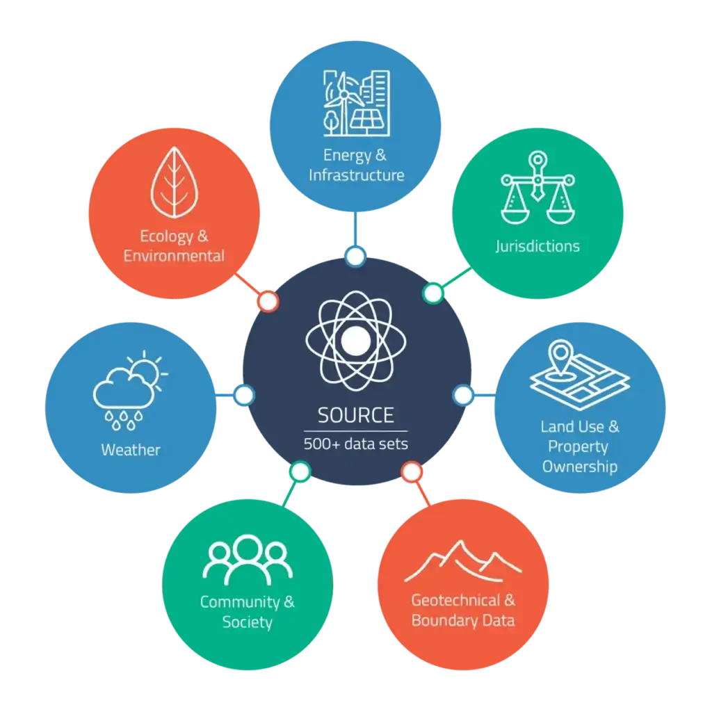
Source offers access to more than 500 geospatial datasets. Organizations can select the data that supports their priorities or license a broader collection across these categories. View Data Layers:
Source is a Data as a Service (DaaS) offering that provides curated geospatial data for use in your organization’s own tools, applications, analytics, cloud environment, or enterprise systems. It gives teams access to trusted location intelligence without requiring them to source and prepare every dataset internally or conduct their work in the Pivvot software platform.
Who is Source designed for?
Source is designed for organizations that need reliable location intelligence data, whether they have a mature GIS program, a small data team, limited specialist resources, or no dedicated GIS function. It can support data, analytics, product, technology, operations, planning, engineering, environmental, land, strategy, and executive stakeholders.
Does Source replace our GIS or other enterprise systems?
No. Source supplies curated location data for use within the systems and workflows your organization chooses. It can extend existing GIS, cloud, analytics, business intelligence, and enterprise environments.
Can we select individual datasets?
Yes. Select the data that supports your projects, systems, applications, and business priorities. You may license selected datasets or a broader collection from the Pivvot data library.
How is Source delivered?
Delivery can be aligned to your requirements and may include API access, cloud-based delivery, secure file transfer, bulk data delivery, and custom integration. Availability will be confirmed for the selected datasets and intended use.
What use cases can Source support?
Source can provide location-based inputs for risk and due diligence, investment planning, operational intelligence, site and market evaluation, infrastructure and network planning, environmental and land analysis, enterprise analytics, application enablement, and data standardization.